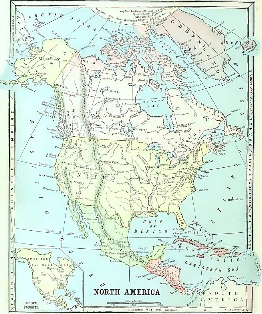
North America is situated in the Western Hemisphere, and lies chiefly in the North Temperate Zone.
Its most northern part is in the North Frigid Zone, and its most southern, in the Torrid Zone.
Its widest part is in the north.
Its direction from South America is northwest; from Europe, west; and from Asia, east.
Its shape is that of a triangle, and its three sides are bounded by three oceans—the Arctic, Atlantic, and Pacific.
Its size is twice that of Europe, or one-half that of Asia.
Large regions or countries in North America include Canada, the United States, Mexico, Greenland, Central America, and the Caribbean.
Greenland is a cold, barren region, historically inhabited by Eskimos, whose occupations were fishing and seal hunting.
Greenland's European settlements occurred on the western coast.
Greenland's eastern coast is constantly enclosed by ice.
Canada is the largest sized country in North America.
Canada's northeastern half is covered with ice and snow much of the year.
Its remaining part contains vast forests and prairies, where the buffalo, elk, deer, beaver, mink, and other animals, are hunted for their furs.
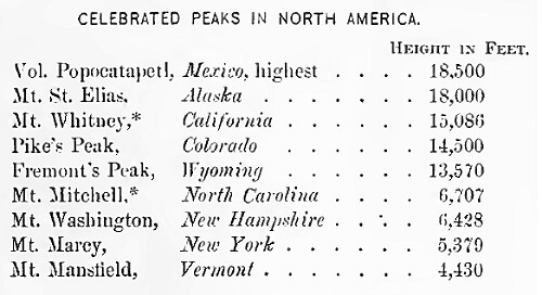
MOUNTAINS
The highest mountainous section of North America is in the west.
Its great mountain system extends from the Andes, in South America, in a northwesterly direction, to the Arctic Ocean.
The mountain ranges are mainly parallel with the seacoasts.
The Rocky Mountains rest on a great plateau which extends westerly to the Sierra Nevada and Cascade Mountains. Their greatest distance from the Pacific coast is about 1000 miles. In the United States they are about midway between the Pacific Ocean and the Mississippi River. The plateau is about one mile above the level of the sea.
The highest peaks of the Rocky, Sierra Nevada, and Cascade Ranges are so high that they are continually covered with snow.
This section was once celebrated for its wealth in gold, silver, and quicksilver mines. In the valleys near the Pacific coast the soil is very productive and the climate delightful.
The most important mountains in the eastern part of North America are those of the Appalachian system, which comprises several ranges extending in the same general direction as the Atlantic coast.
SLOPES, PLAINS, AND RIVERS
The great plains and lowlands of North America extend from the Atlantic Ocean to the Gulf of Mexico, and from the Rocky to the Appalachian Mountains.
The great plains and lowlands comprise four basins; those of the Mississippi, the St. Lawrence, Mackenzie River, and Hudson Bay. Which of these basins are on the Atlantic slope? Which is on the Arctic slope?
From the base of the Rocky Mountains to the Mississippi River, the descent is hardly perceptible, being a fall of only one foot in a mile.
The Pacific Slope of North America is that part which is west of the Rocky Mountains.
The Pacific Slope is drained mainly by the Columbia, Colorado, and Yukon Rivers.
From the Appalachian Mountains to the Atlantic Ocean, the slope is gentle, being first hilly, then level, and near the coast, low and swampy.
The Atlantic Slope, on account of its soil, streams, lakes, and inlets, is well adapted to agriculture, manufacturing, and commerce.
CLIMATE AND PRECIPITATION
The climates of North America are of every variety; tropical in the south, frigid in the north, and temperate in the middle.
The climate of the Pacific Coast, in the United States, Canada, and Alaska, is much milder than that of the Atlantic coast, in corresponding latitudes.
Winds partake of the temperature of the surface over which they blow. The land is warmer in summer and colder in winter than the ocean; that is, the temperature of the ocean is more uniform throughout the year than that of the land. And as the prevailing winds in the Temperate Zone are from the west, their temperature will be milder on the Pacific than on the Atlantic coast.
The Rain of the Pacific coast is supplied by vapor which rises from the Pacific Ocean.
On the Pacific coast of the United States the rain falls between that coast and the Sierra Nevada mountains, because the vapor is condensed before passing: over the cold peaks of that high range, thus leaving a vast elevated region east of the Sierra Nevadas, from the Columbia to the Colorado river, destitute of rain.
The rain of the Atlantic Slope is supplied from the Gulf of Mexico and the Atlantic Ocean.
VEGETATION
In the cold or northern regions, the vegetation is very scanty.
In the hot or tropical regions it is very dense, owing to the excessive heat and moisture.
ANIMALS
The principal animals of the north are the polar bear, reindeer, whale, walrus, and seal.
Animals commonly found in the south include alligators, turtles, and rattlesnakes.
Among the wild animals of the temperate regions are bears, buffalos, deer, and wolves.
MAPWORK
Point out the places on the map.
Mountains:—Rocky, Alleghany, Sierra Nevada, St. Elias.
Rivers:—Mississippi, Missouri, Rio Grande, St. Lawrence, Colorado, Columbia, Yukon.
Gulfs and Bays:—Gulf of St. Lawrence, Bay of Campeche, Bay of Honduras. Gulf of Mexico, Hudson Bay, Baffin Bay.
Straits:—Hudson, Davis, Behring, Florida.
Lakes:—Superior, Great Slave, Great Bear, Winnipeg, Michigan, Ontario, Erie, Huron.
What country and gulf are crossed by the Tropic of Cancer?
Through what country does the parallel of 40' north latitude pass?
Through what large bay does the parallel of 60° north latitude pass?
On which side of North America are its long mountain ranges? Name those ranges.
On which side of North America are its large gulfs and bays? Name them.
What capes project into the Arctic Ocean? Into the Atlantic Ocean? Into the Pacific Ocean?
Name the countries of North America.
What type of landform is Greenland? Ans. An Island.
What large rivers are west of the Rocky Mountains?
What large rivers flow into the Gulf of Mexico?
What river flows into the Arctic Ocean?
What capes would you pass on a voyage from Philadelphia to Savannah?
What islands would you pass on your way from New York to Cuba?
What islands would you pass on your way from Boston to Quebec?
On what waters would you sail from Savannah to New Orleans? From Quebec to Haiti? From New York to Baffin Bay?
GENERAL DIRECTIONS FOR DRAWING CONTINENTS
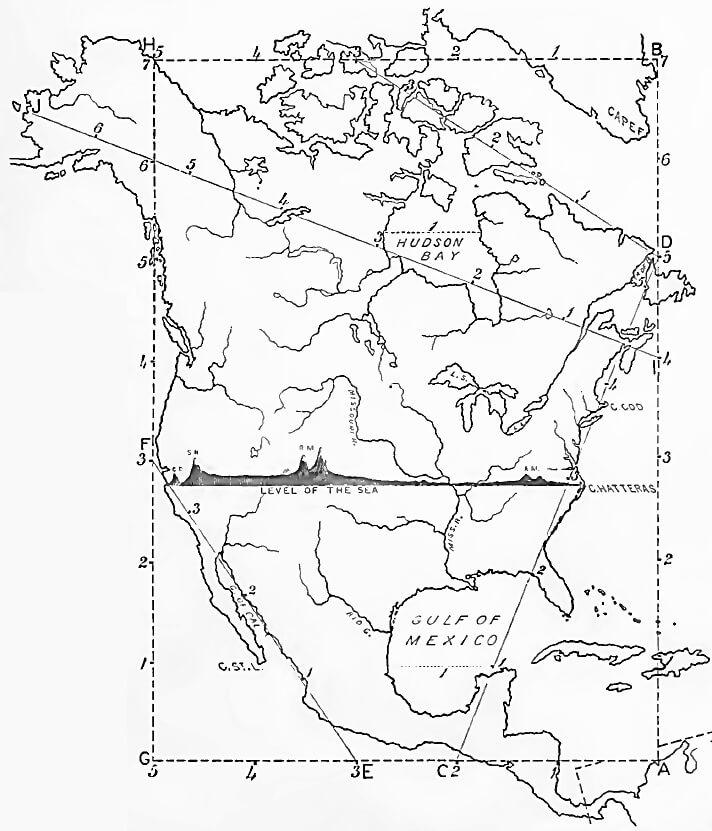
Make a scale by marking on a slip of paper the measures 1, etc., as on the sides of this map. Every measure on the maps of the continents represents six hundred miles.
All names in black type are to be marked on the drawing.
Pupils should mark on each river, ocean, bay, gulf, strait, etc., the first syllable of its name, when there is not enough room for the full word. As an exercise in spelling, the full name of each abbreviated word may be written on the margin of the drawing, before the recitation closes.
Note.—Do not draw the measurement lines. The marking of the points indicated will be sufficient.
DRAW NORTH AMERICA
Draw North America on pg. 10 in your notebook as directed.
Begin at A: 1 measure north of A, draw Haiti; 5 measures north, draw Newfoundland and the Strait of Belle Isle. Between 6 and 7 draw the eastern coast of Greenland.
From C measure to D, marking the points 1, 2, 3, 4, 5. Through 1 draw the northern extremity of the Peninsula of Yucatan. 1 measure west of this point draw the western coast of the Gulf of Mexico. Draw Campeche Bay, the Bay of Honduras, and the Isthmus of Panama and Cuba.
At 2 draw the Peninsula of Florida. Mark 3 on the line C D, and locate Cap Hatteras. Near 4 mark Cape Cod. Near 5 draw the Gulf of St. Lawrence and Nova Scotia and complete the eastern coast. From B measure 5 measures to H and draw the islands along the Arctic coast.
From G, measure north 3 measures, and mark San Francisco: and a little to the north, Cape Mendocino, the western cape of California; opposite 4 draw Vancouver's Island: at 5, Queen Charlotte's Island. 7 is near the northeastern coast of Alaska.
From E toward F, mark the points 1, 2, and 3, and draw the Gulf and Peninsula of California and Cape St. Lucas. Complete the southern coast of the continent.
Draw James Bay, Hudson Bay, Great Slave Lake, and Mackenzie River, according to the line I J, and complete the northern part of the continent.
When the boundaries are drawn, add the mountains, rivers, countries, bays and gulfs, capes, islands, and cities; then the section from Cape Hatteras to the Pacific Ocean, showing elevations above the level of the sea.
 Comprehensive Geography
Comprehensive Geography
Comprehensive Geography


 About
About Curriculum
 Navigation